Air Force Home Page New Sarum Air Base Thornhill Air Base Site Home Page"
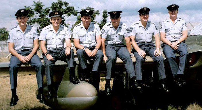
PHOTO SECTION, NEW SARUM, C1972

Left to Right
Paddy O'Reilly - Cedric Herbert - John Bromley - Jerry Duncan - Steve Harvey - Syd Myers
Photo sent by Jenny Buxton (O'Reilly) via ORAFS.
A HISTORY OF PHOTO SECTION, NEW SARUM
1. The first RRAF (Royal Rhodesian Air Force) Photographic Section was established at Cranborne in 1950, and was housed in a single large room next to the aircrew living quarters.
Condition's were primitive to say the least; the nearest running water was from an outside tap some thirty yards from the section, and was collected in buckets. The whole section was converted into a darkroom by turning off the light; but it was not dark for long since visibility soon returned via diffused lighting from the many cracks in the ceiling and window frames. It was, in fact, ideally suited to photographers afraid of the dark.
2. In spite of the problems, many square miles of photo cover was flown and supplied to various government departments, using the Harvard and Rapide aircraft. Processing air film 165 feet in length and 9½ inches wide was quite an adventure; after posting a large "Keep Out" sign on the door, the film was hurried through the developing process before it became affected by the extraneous lighting. Final film washing was carried out under the hydrant behind the Fire Section before returning to the darkroom, where it was placed on the huge drying drum, five feet in diameter and eight feet long, which occupied a large percentage of the floor space. Other activities included production of cine gun training films, defect report photography, Boards of Inquiry photos, and pictures for Service history and publicity display.
3. The section moved to New Sarum during 1952. In 1955, "the Rapide gave way to newly-converted Dakota aircraft, and the photographic staff was increased to cope with the additional and steadily increasing demands. Many interesting and valuable aerial photographic sorties were flown at this time, including a hydrographic survey of the upper reaches of the Zambezi during flooding to record high water levels, a route survey of the new road to Kariba, and a low-level survey of Salisbury city; measurements being made, from the resulting prints, down to a few inches for a large scale ordnance map. Print production increased to an average level of 25,000 contact prints and enlargements per year.
4. In 1957, a second section was established at Thornhill to satisfy the demands for technical photography at that Station, and to provide facilities for all cine gun training and assessment. In 1961 the first trials using the Canberra for high-altitude aerial survey and photo reconnaissance were successfully carried out at Thornhill.
5. With the arrival of No, 5 Squadron at New Sarum, the formation of a full-time photo-interpretation section, the production of air photography was stepped up. It was intended that by the end of the year about 130,000 square miles of survey cover would have been completed for Government survey needs alone, and a considerable amount for training and other Air Force purposes. Cameras used had interchangeable lenses varying from a 6 inch wide-angle lens capable of photographing, at 50,000 feet, 200 square miles of territory on a single negative, to a 36 inch telephoto lens used to obtain detailed reconnaissance information. In addition to these fixed camera installations, hand-held cameras were employed in Provosts and Alouettes for oblique target photography and low-level reconnaissance. In later years the F95 camera on the Hunter provided low level photographic capabilities.
6. The service photographer always laid claim to one of the most interesting and absorbing jobs in the Force. He was called upon to provide aerial or ground photographs of an infinite variety of tasks from document reproduction and identity pictures to a minute fracture of a pipe located in an inaccessible part of an aircraft, or, on those all-too-rare occasions, to provide pin-up shots for Ndege. He had to have an intimate knowledge of photographic theory embracing both optics and chemistry, and the thorough understanding of at least half a dozen air cameras. He had to be part artist and part technician in a profession which, being essentially creative, can pose a new problem every day requiring imagination and skill.
AERIAL PHOTOGRAPHY
1. Whilst it was generally known that modern map-making techniques involved the use of air photographs, it was not fully appreciated that the RRAF haD the task of photographing Rhodesia for mapping purposes. A considerable percentage of the country's topographical mapping was based on out-dated information originally gathered by field survey parties, and the Government Survey Department was constantly revising all such mapping.
2. Liaison between Surveys end HQ RRAF resulted in photographic requirements being channelled, in the form of Air Tasks, to the Photo Flight of No. 5 Squadron. The task was then flown with a Canberra equipped with a fixed vertical survey camera remotely controlled from the bomb aimers position. The camera was electrically driven, and "triggered" at a regular time interval determined by an intervaloraeter under the control of the photo-navigator.
3. The area to be photographed was divided into "flight lines" along which the aircraft tracks, taking a continuous strip of photographs at a time interval so calculated that the area of ground covered by each photograph overlapped the area cover of the proceeding one by 60%. Similarly, the flight lines were constructed so that adjacent strips of photographs overlap by 30%.
This overlapping system was designed to ensure that all ground detail was covered on at least two photographs (providing sterescopic cover, which is the basic requirement for mapping), and also to ensure that minor navigational errors did not result in gaps.
As well as photo surveys for the Government map-makers, the RRAF carried out an incredible variety of photographic tasks which varied from Canberra sorties above 50,000 feet, to the use of a hand-held Rollieflex in a helicopter at 100 feet. Our photographic capabilities were used by the Police, Army, Government departments such as Mines, Tourism, Tsetse Control, Agriculture, and even town-planning authorities.
Aerial photography in the RRAF certainly came a long way since the early days when photo crews were greeted with derisive shouts of "Happy Snaps".
It was not generally appreciated that an extremely high standard of flying accuracy was required in aerial photography. Deviations in height, speed, aircraft attitude, and navigational errors could all render the resulting film unusable. For example, a one-degree heading error would result in photographic cover gaps on a long flight line. The camera never lies, and all such flying errors were faithfully recorded on the film. Similarly, correct and precise flying was also recorded, and such films were naturally a great source of satisfaction to the crew. Although aerial photography is one of the most exacting of all flying tasks, it is also probably the most rewarding.
A PILOT'S VIEW OF THE PHOTO SECTION, by Ed Potterton
Like every other pilot who flew in the Rhodesian Air Force for the last ten years of its existence, I benefited greatly from the fantastic work carried out by both 5 Squadron and the Photographic Section. I flew for my last five years in the Air Force at very low level, using the very maps mentioned above. The accuracy of the 1: 50,000 maps in particular was amazing, and we were able to navigate "to the inch" while flying at 50 feet or lower. I was always amazed at the thought that the whole country had been mapped in the manner described above.
In 1980 when the RAF came to the new Zimbabwe/Rhodesia to help with the year of transition, I was stunned to discover that they arrived with 1: 50,00 maps as good as ours. Dare I say it, I think they were slightly better in that every clearing in the bush was accurately shown. They of course had had the benefit of satellite mapping. And yet, the scaling, positions of rivers, hills etc., were no more accurate than in our maps using much more tricky technology.
In fact, I remained proud and lost in admiration for the two units who produced our maps, without which we could not have conducted our anti terrorist campaign.


